
Imagine standing at the foot of the towering snow-capped peaks that have watched over the land for millions of years, their uneven edges aged away over time. The Karakoram Range is a magnificent masterpiece of nature that holds the secrets of ancient geological forces in its vastness. But how did the Karakoram Range form? We take a journey to unravel the untold story of these giants. Where adventure meets mystery, every turn of land has a tale to tell. Also, ready to explore one of nature’s most captivating landscapes of nature?
Read More: Complexities of Climbing Unclimbed Peaks of Karakoram
How did the Karakoram Range Form?
Geological Mystery
What if I told you that the collision of continents created the world’s most dramatic mountain range? The Karakoram Range is where earth-curving mountains like K2 have rugged, wild power, and its story is as thrilling as any adventure. Moreover, the origin of the Karakoram Range relates to the most dramatic story of mountain forming forces that reshape and remold the surface of the Earth.
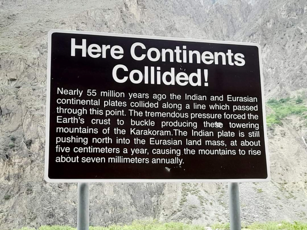
More than 50 million years ago, the Indian plate began its grand journey northward, to collide with the Eurasian plate. It was not only the creation of a mountain range as a result of this collision, but it also took the form of a geological revolution. It also gave rise to some of the most stunning peaks in the world.
Astronomy of Karakoram Range
The deforming and folding of the earth’s crust had to occur under the crushing impact, with the Indian plate pressing against the Eurasian one. Owing to this geological collision, huge rock formations rising upwards pushed them skywards and caused the name Karakoram Range. The geological activity of folding, structural break, and metamorphosis went on for many millions of years rather than this.
The Formation of Karakoram’s Peaks
The uplift caused by tectonic collision created many of the world’s highest peaks, each with its own unique geological story to tell.
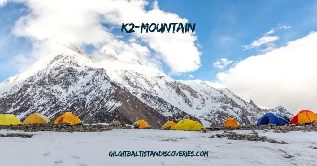
K2-Mountain | Godwin Austen
K2 rises to 28,251 feet, or 8,611 meters high, and was one of the first peaks to reach its remarkable height. Steep and rugged. Hence, it has become an almost supernatural challenge for adventurers.
Read More: Ali Sadpara, two other mountaineers missing on K2 declared dead
Broad Peak
At 26,414 feet, Broad Peak was a huge mass of rock and stone, its wide peak adding to the beauty of the Karakoram skyline.
Gasherbrum I and II
At 26,509 feet and 26,361 feet above sea level respectively, these peaks were also formed by the unstoppable geological forces acting on the range.
Ice and Glaciers
The glaciers are one of the most effective land-modeling features in Karakoram. Glaciers like Baltoro, Siachen, and Biafo show deep valley records within them, and the topography of the region molded over thousands of years. These huge ice fields also flow through the mountains, creating a breathtaking scene of forming ice that molds the geology of the region.
Geological Layer -A Story Written Into The Rocks
The Karakoram Range presents a geological layout because of the different types of rocks forming it, including:
Ancient Granites and Gneisses
The Ancient Granites and Gneisses formed during the early phases of mountain building and form the core of the Karakoram. Hence, some of the oldest geological formations in the region.
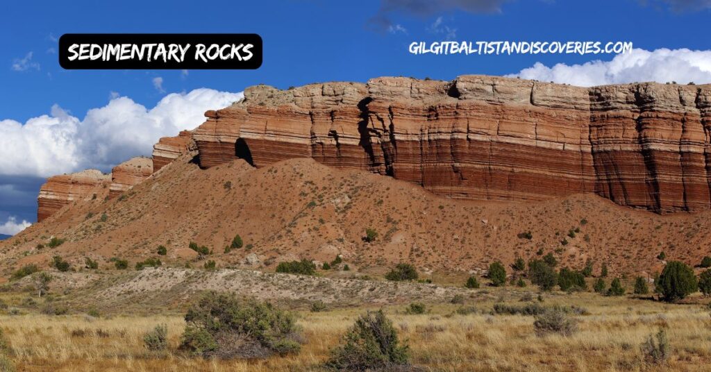
Sedimentary Rocks
The overlying limestone, shale, and sandstone strata formed over many millions of years are additional layers of rock added to the geology of the range, a tapestry of complexity and depth.
Evolving Range-A Dynamic Landscape
This range develops right up to our times. The fact that tectonic activity continued right into the present times means that the mountains continue growing at a speed microscopically small. Indeed, Earthquakes and other geological activities often reshape this range and keep it among the most dynamic and curious geological features in the world.
Exploration and Adventure
Enter a world of limitless adventure! The Karakoram Range invites you to imbibe an exciting sense of discovery, fascinating you with the certain magic of the mystery. Come face to face with K2, the second-highest mountain in the world, and walk across the glaciers, which whisper stories of journeys past. Every serrated ridge, every ice surface can be an invitation to lifelong stories and remembered moments. So, get ready and let the Karakoram make your adventure a legend in itself.
From early adventures through modern geological surveys, centuries of curiosity among explorers and scientists alike have given the formation of the Karakoram Range an in-depth understanding of its formation. In addition, bringing about major findings into Earth’s processes and the forces that wonderfully shape our planet.
Read More: Complete List of Mountains in Pakistan and Their Ranking
Conclusion-Karakoram Range
From the early collisions of crustal giants to the refined glory of their towering peaks and shimmering glaciers. The Karakoram Range crowns itself as a geological wonder that commands wonder. As one enters this extra world, remember that one stands before a masterpiece always in evolution reporting to raw power and artistry by the planet Earth.
Prepare to be captivated by the dignity and charm of the Karakoram. A land where every peak narrates a tale and every glacier speaks in soft tones of ages past. Moreover, this is not a mountain range, it’s a dramatic life, awaiting your presence and preparing to excite and overwhelm you.
Read More: Mountain Climbing in Gilgit-Baltistan
Frequently Asked Questions Karakoram Range Formation
1. What is the Karakoram Range?
The Karakoram Range also includes one of Asia’s grand mountain systems of Asia, stretching for about 300 miles (500 km) in a southeasterly direction from the northeasternmost corner of Afghanistan. Famous for its peaks and giant glaciers, the range forms part of a greater mountain complex along with the Hindu Kush, the Pamirs mountain ranges, the Kunlun Mountains, and the Himalayas.
2. What is the origin of the Karakoram Range?
The origin of the Karakoram Range was a result of a tectonic plate collision between India and Eurasia. The collision of these tectonic plates, which began over 50 million years ago, folded, faulted, and uplifted the Earth’s crust. In addition, developing the dramatic peaks and rugged topography of the Karakoram.
3. What are some of the high peaks of the Karakoram Range?
Some of the known peaks in the Karakoram Range include:
- K2 or Mount Godwin Austen: Its height is 28,251 ft or 8,611 meters and is the second-highest peak in the world.
- Broad Peak: It is 26,414 feet or 8,051 meters.
- Gasherbrum I and II: They measure 26,509 feet or 8,080 meters and 26,361 feet or 8,035 meters respectively.
4. What role do the glaciers play in the Karakoram Range?
Glaciers, which also include Baltoro, Siachen, and Biafo in the Karakoram. Also have immensely altered topography in the shape of valleys and ice formations. They also contribute to hydrology by resupplying major rivers with their melting water.
5. What kind of rocks does one find in the Karakoram Range?
It contains the following kinds of rocks:
- Core: Its core is older and consists of Granites and Genisses.
- Sedimentary Rocks: These include Limestone, Shale, and Sandstone lying over the older ones to contribute towards the geological diversity of the range.
6. Has the Karakoram Range changed?
Yes, it does, as the Karakoram Range is yet to develop properly. With continued tectonic activity, the mountains rise progressively and seismic events take place that shape and reshape the region.
7. What is the weather like in the Karakoram Range?
This range has a very varied climate, for the southern slopes receive monsoon winds with precipitation, while the northern slopes are very dry. Most precipitation falls as snow gets higher up, with temperatures quite frequently below freezing in these high-altitude snowfields.
8. In what way has exploration contributed to our understanding of the Karakoram Range?
Indeed, exploration and scientific studies have provided an enormous amount of information on how the range originally came into being and its general geology. More importantly, early European expeditions and modern geological surveys mapped the range and also studied its dynamics.
9. What is special about the Karakoram Range?
The Karakoram Range bears both geological and geopolitical significance. It also contains some of the highest peaks in the world with vast glaciers. They are considered a natural boundary separating many countries, including Pakistan, India, China, Afghanistan, and Tajikistan. It is also considered to be highly focused on extreme topography and conditions for mountaineers and researchers.
10. Is the Karakoram Range able to be experienced by people?
Yes, the Karakoram Range has been also one of the favorite places visited by trekkers, climbers, and other people with an adventurous attitude. Popular routes include treks to base camps at K2 and other high peaks. These peaks also include exploration of spectacular glaciers and valleys in the range.