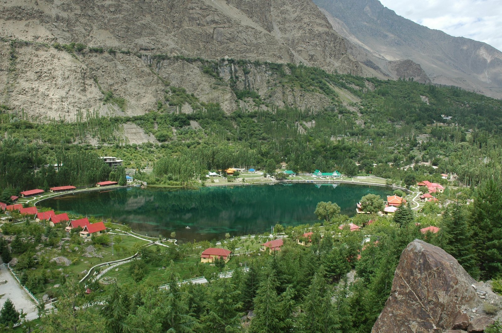
Short Answer
Gilgit City is the capital of Gilgit-Baltistan and the place where almost every northern Pakistan trip passes through, stocks up and changes direction. It is a working crossroads city, not a resort: a busy bazaar, two famous bridges, a 7th-century Buddha carved into a cliff, and roads heading toward Hunza, Skardu, Ghizer and Chitral. Stay one or two nights at the start or end of a trip — longer only if you are using it as a base for Naltar or for Ghizer’s valleys. April to October is the practical window; summer days in the city are warm and dry, and winter can disrupt flights and mountain roads.
Where is Gilgit City?
Gilgit City sits in Gilgit District, Gilgit-Baltistan, in a broad valley near the confluence of the Gilgit River and the Hunza River, at an elevation of about 1,500 m. It is the capital and most-populous city of Gilgit-Baltistan; the 2011 population figure recorded for the city is 261,440, so treat any current figure as needing a newer census, not as a fact of today. Gilgit was once a major centre for Buddhism and an important stop on the ancient Silk Road, and today it is a major junction along the Karakoram Highway, with road connections toward Kashgar in China and toward Skardu, Chitral, Peshawar and Islamabad. Hunza and Nagar are separate districts and valleys to the north-east — do not confuse them with Gilgit itself, even though the same highway serves them all.
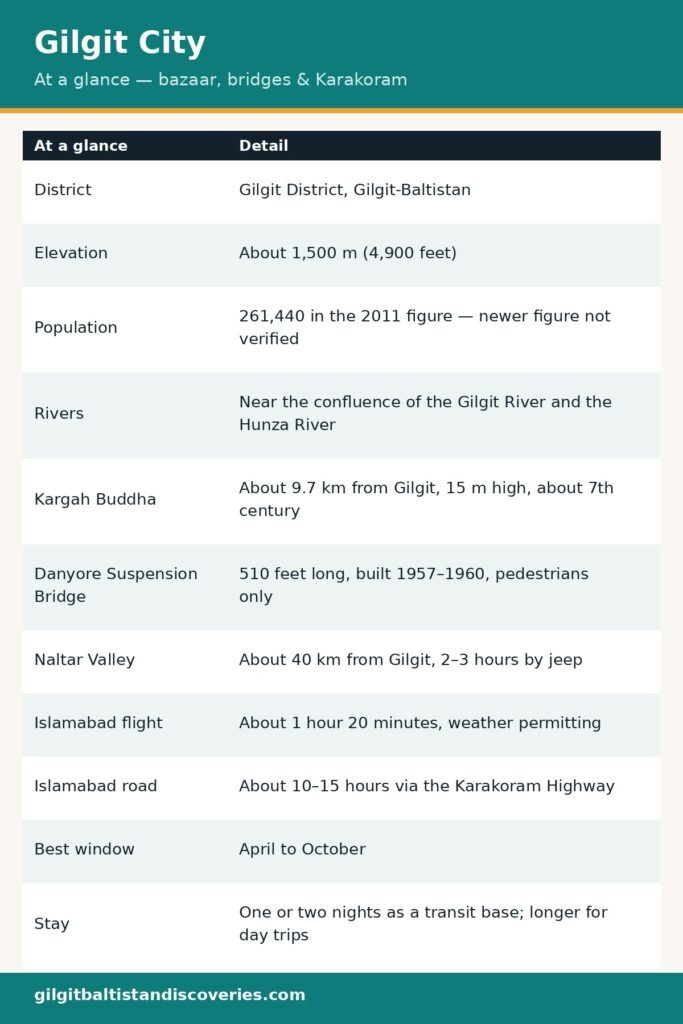
| Gilgit City at a glance | Detail |
|---|---|
| District | Gilgit District, Gilgit-Baltistan |
| Elevation | About 1,500 m (4,900 feet) |
| Population | 261,440 in the 2011 figure — newer figure not verified |
| Rivers | Near the confluence of the Gilgit River and the Hunza River |
| Kargah Buddha | About 9.7 km from Gilgit, 15 m high, about 7th century |
| Danyore Suspension Bridge | 510 feet long, built 1957–1960, pedestrians only |
| Naltar Valley | About 40 km from Gilgit, 2–3 hours by jeep |
| Islamabad flight | About 1 hour 20 minutes, weather permitting |
| Islamabad road | About 10–15 hours via the Karakoram Highway |
| Best window | April to October |
| Stay | One or two nights as a transit base; longer for day trips |
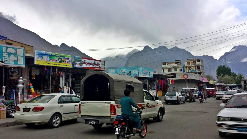
What is the Gilgit bazaar like?
A working market, not a tourist show
Gilgit’s old bazaar, at the end of the traditional bazaar area near the Gilgit River bridge, is where the city earns its keep. This is where travellers buy supplies, gemstones and local crafts, and where local people do their weekly shopping. It is busy, loud and practical: dried fruit and nuts, woollen caps, jackets, trekking snacks, SIM cards and spare batteries sit side by side. The NLI market is part of the same commercial core. Come in the morning, when the light is good and the stalls are fully stocked, and bargain politely — a first price is an opening, not an insult.
What to buy here, and what to skip
Buy here what the valleys will not sell you: a local SCOM SIM (passport details required, use an official franchise), small-denomination rupees, sun protection, snacks and any forgotten layer. Skip anything you cannot verify on the spot — gemstone claims in particular need a reputable dealer and a receipt, and a bazaar stall is not the place to test that. If you are heading into Ghizer, this is also the last reliable place to change money and buy trekking food before the smaller valley markets take over.
Which bridges should you see?
The Danyore Suspension Bridge
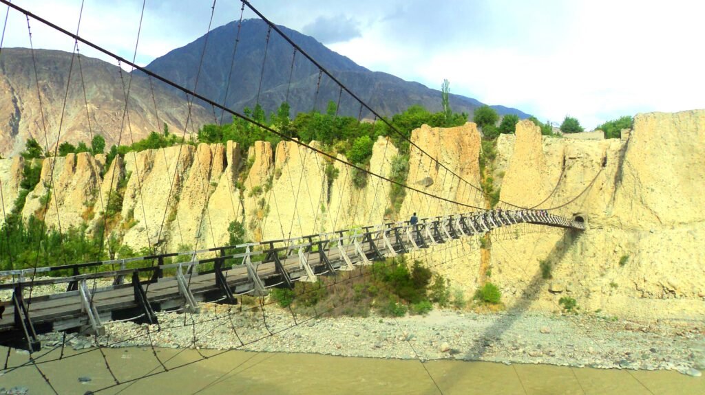
The Danyore Suspension Bridge — also called the Bireno Bridge — crosses the Hunza River and links Danyore with the Karakoram International University side. It is 510 feet long and 8 feet wide, was built between 1957 and 1960 by self-taught local engineer Ahmed Ali, known as Thakedar Bereno, and is reached through a 10-metre curved, non-cemented tunnel, above which sits the shrine of Saint Shah Sultan Ali Arif. It is locally known as Pul-e-Sirat, the bridge between heaven and hell. It is now closed to traffic and open to pedestrians only — walk it slowly, hold the rails, and do not cross in high wind.
A note on the bridge’s recent damage
A fire in March 2025 damaged about 30% of the Danyore Bridge’s wooden structure, according to Dawn’s reporting at the time, and electrical wires across the bridge burned. The bridge was reported structurally intact from the top, but the lower portion was damaged. Ask locally whether repairs are complete and the bridge is fully open before you plan a crossing — this guide does not claim a current open-or-closed status that has not been re-verified on the ground.
The Gilgit Bridge
The older Gilgit Bridge crosses the Gilgit River at the end of the traditional bazaar. Older guidebooks describe it as one of the largest suspension bridges in Asia, at 182 metres long and 2 metres wide, wide enough for one jeep at a time — a claim this guide repeats only as a historical guidebook description, not as a verified current ranking. Walk it for the river view and the bazaar end, and treat any “largest in Asia” claim from a local guide with the same caution.
What is the Kargah Buddha?
The carving
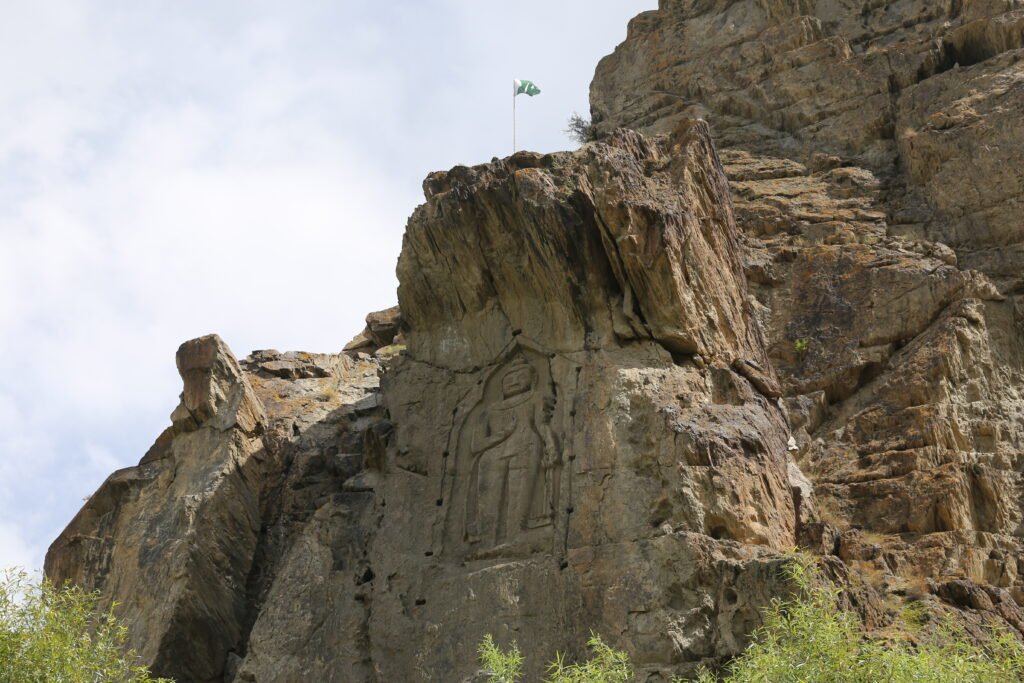
About 9.7 km west of Gilgit, in the cliff face of Kargah Nala, stands the Kargah Buddha: a carved image of a standing Buddha some 50 feet (15 m) high, estimated to date back to the 7th century. The image is surrounded by holes for a wooden shelter structure that once protected it from the weather. It is an easy short drive from Gilgit town, and the site is open to visitors. Go in the morning for the best light on the cliff face, and combine it with a drive out toward Naltar or a bazaar afternoon rather than making it a full day on its own.
Why it matters
From the 3rd century to the 11th century, Gilgit was a prominent centre of early Buddhism, and the Kargah site sits within that history: nearby, about 400 metres upstream, a Buddhist monastery and three stupas containing Sanskrit manuscripts were excavated in 1931. The Gilgit manuscripts found in this area are among the oldest surviving Buddhist manuscript collections from the Indian subcontinent. Locally the figure is also known as Yashani, linked to a folk legend of a man-eating giantess pinned to the cliff by a holy man — a reminder that Buddhist heritage and local folklore share this cliff, and both are worth hearing from a local guide rather than from a plaque alone.
How do you get to Gilgit, and where next?
By air, with a weather warning
The quickest way to Gilgit is the flight from Islamabad to Gilgit Airport, about 1 hour 20 minutes, operated by Pakistan International Airlines. Availability is subject to weather conditions, and Gilgit flights are famously cancellable: mountain weather, not the timetable, decides whether you fly. Never plan a tight onward connection on a Gilgit flight day, and keep the road as a fallback. If you fly in, spend the first night in Gilgit rather than driving straight on — altitude, fatigue and a cancelled return all argue for the buffer.
By road, and onward in every direction
By road, the Karakoram Highway links Gilgit with Islamabad, a long drive often split over two days — about 10 to 15 hours by public transport or taxi, depending on traffic and road work. From Gilgit, the same highway system branches in every useful direction: north toward Hunza District and the Khunjerab Pass, east toward Skardu, west toward Ghizer District (Gahkuch, Phander, Yasin and Ishkoman) and Chitral, and south toward Chilas and Islamabad. That is why Gilgit works as a base: you are not choosing a valley here, you are choosing which road to take tomorrow.
What day trips work from Gilgit?
Naltar Valley
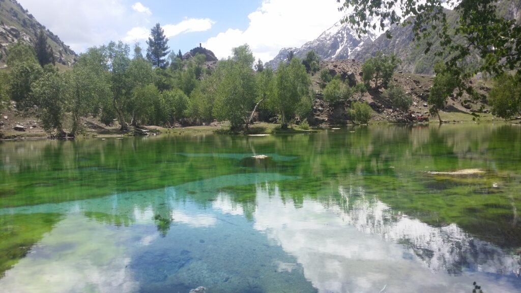
Naltar Valley is the classic Gilgit day trip — or better, an overnight. It sits about 40 km from Gilgit, and the jeep journey takes about 2 to 3 hours, depending on road conditions, because the road is rough and unpaved in many places. Naltar offers alpine forest, small lakes including Satrangi Lake, and a ski area in winter; May to September is the best window for the lakes, while December to February suits snow lovers with a 4×4. Hire an experienced local driver from Gilgit town, and do not attempt the upper road in a low-clearance car.
Ghizer’s valleys and the Chinese cemetery at Danyore
West from Gilgit, the Ghizer road leads to Gahkuch, the district headquarters about 73 km away, and onward to Phander, Yasin and Ishkoman (see the companion Yasin Valley guide and Ishkoman Valley guide). Near Danyore, on the Karakoram Highway side, sits the Chinese cemetery — a memorial site reflecting the history of Karakoram Highway construction, when Chinese and Pakistani engineers built the road through these mountains. It is a quiet, respectful stop, not a photo opportunity: visit briefly, behave accordingly, and combine it with the Danyore Bridge walk.
Where to stay and eat
Gilgit has the north’s widest range of stays, from guesthouses to larger hotels, and it is the right place to spend a comfortable night after a flight or before a valley drive. This guide names no hotel prices or room claims, because those change seasonally and were not re-verified for this draft — ask locally or check current listings before booking. Food in Gilgit is the north’s full menu in one city: chapshuro, momos, karahi and daal with roti, plus dried fruit and nuts from the bazaar. Eat in the bazaar area for the liveliest choice, and carry cash in small notes: working ATMs effectively stop at Gilgit and Skardu, and beyond the towns there are none at all.
Practical tips for Gilgit City
- One or two nights, then move on: Gilgit earns its keep as a base and a supply stop. A longer stay makes sense only if you are day-tripping to Naltar or waiting out a flight.
- Buy the SIM and the cash here: A SCOM SIM bought in Gilgit (passport and visa copy required) and a generous stack of small-note rupees are the two purchases that decide whether the rest of the trip runs smoothly. See What to Pack for Northern Pakistan.
- Never trust a Gilgit flight date alone: Keep a road fallback and a spare night in hand. Weather cancellations are normal, not exceptional.
- Visas and permits: Open valleys need no special permit beyond a tourist visa for most foreign visitors, but restricted trekking country is different. The general position is set out in the Pakistan Tourist Visa Guide.
- Pack for the city and the pass in one bag: Gilgit days are warm, but every onward road climbs fast. A KEEN Targhee 3 boot for valley paths and an Anker PowerCore power bank for long road days cover the two most common Gilgit regrets.
Frequently Asked Questions
Where is Gilgit City?
Gilgit City is in Gilgit District, Gilgit-Baltistan, in a broad valley near the confluence of the Gilgit River and the Hunza River, at about 1,500 m. It is the capital of Gilgit-Baltistan and a major junction on the Karakoram Highway, with roads toward Hunza, Skardu, Ghizer and Chitral.
What is the Kargah Buddha?
The Kargah Buddha is a standing Buddha carved into the cliff face of Kargah Nala, about 9.7 km west of Gilgit, some 50 feet (15 m) high and estimated to date to the 7th century. Nearby, a monastery and three stupas with Sanskrit manuscripts were excavated in 1931, marking Gilgit’s early Buddhist history.
How long should I stay in Gilgit City?
One or two nights is enough for most travellers — time to visit the bazaar, the Danyore Bridge and the Kargah Buddha, and to stock up before heading onward. Stay longer only if you are day-tripping to Naltar, waiting out a flight, or using Gilgit as a base for Ghizer’s valleys.
Is the Danyore Suspension Bridge open?
The Danyore Bridge is 510 feet long, was built between 1957 and 1960, and is open to pedestrians only, not vehicles. A fire in March 2025 damaged about 30% of its wooden structure, so ask locally whether repairs are complete before planning a crossing, as this guide does not claim a verified current status.
What is the best time to visit Gilgit City?
April to October is the most practical window for Gilgit City, with warm, dry summer days in the city and cooler valleys nearby. Winter is cold, and mountain roads and flights can be disrupted, so winter visits need flexible dates and a road fallback, not a tight flight-dependent itinerary.
Last updated: 27 October 2026