Chilas is the town every Karakoram Highway traveller passes through — and almost nobody plans for. It sits on the left bank of the Indus in the rain shadow of Nanga Parbat: hot, dry, historic, and the junction where the KKH meets the Babusar Pass road. This guide covers where Chilas is, how far it is from everywhere you are going, what its weather actually does, and the handful of things genuinely worth your time while you are here — starting with some of the most important ancient rock art in Asia.
The short answer: Chilas is the district headquarters of Diamer District, Gilgit-Baltistan, on the Karakoram Highway at about 1,200 m. It is ~130 km (2.5–3.5 hours) south of Gilgit and about 470 km from Islamabad via the KKH (about 400 km via Babusar Pass in season). Its one unmissable sight is the ancient rock carvings along the highway; it is also the last real town before Raikot Bridge, the gateway to Fairy Meadows. Summers are hot (June–July afternoons average 34–35°C) — most travellers stop for one night on the Islamabad–Gilgit road.

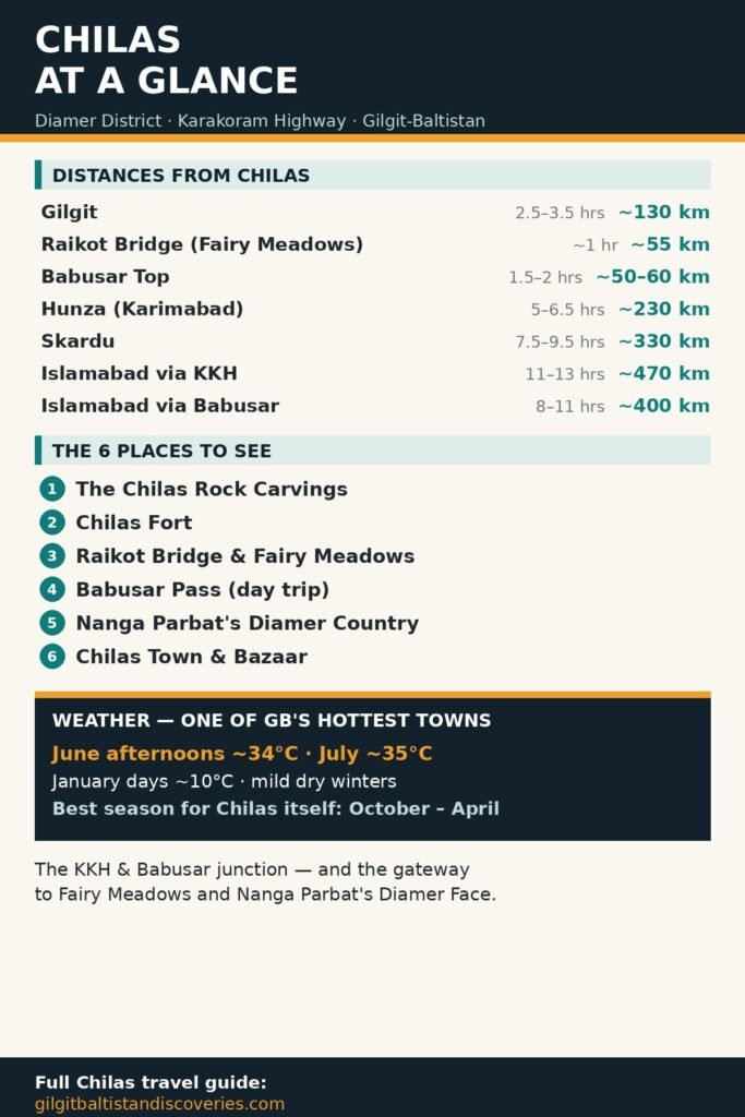
Chilas distances and travel times
| From Chilas to | Distance | Drive time | Notes |
|---|---|---|---|
| Gilgit | ~130 km | 2.5–3.5 hrs | KKH north along the Indus |
| Raikot Bridge (Fairy Meadows) | ~55 km | ~1 hr | KKH north; jeeps to Tato leave from Raikot |
| Babusar Top | ~50–60 km | 1.5–2 hrs | N-15 south; seasonal (roughly late May/June–October) |
| Hunza (Karimabad) | ~230 km | 5–6.5 hrs | Via Gilgit on the KKH |
| Skardu | ~330 km | 7.5–9.5 hrs | Via Gilgit, then the Skardu road |
| Islamabad (via KKH) | ~470 km | 11–13 hrs | The all-weather route |
| Islamabad (via Babusar) | ~400 km | 8–11 hrs | Seasonal; usually split with an overnight stop |
Times are typical driving times in good conditions; landslides and weather can extend any KKH journey. For the full breakdown of reaching the region, see our guide to travelling to Gilgit-Baltistan from Islamabad.
Chilas weather and the best time to stop
Chilas has a cold semi-arid climate: very hot, dry summers and mild, dry winters, because Nanga Parbat blocks the monsoon. Typical daytime highs: January ~10°C · April ~24°C · June ~34°C · July ~35°C · September ~31°C · November ~19°C (climate normals). Nights are far cooler than the afternoons, even in summer.
What that means in practice: if Chilas itself is your destination (for the rock carvings), October to April is the comfortable season. If you are passing through in summer — as most people are, on the way to Fairy Meadows, Hunza or Skardu — plan sightseeing for early morning or evening, carry water, and treat the midday heat as part of the place. Note that the Babusar route to Islamabad only opens in the summer window, while the KKH route is the year-round option.
The best places to visit in and around Chilas

1. The Chilas Rock Carvings (petroglyphs) — The reason to stop. More than 50,000 petroglyphs and inscriptions line the Karakoram Highway in Gilgit-Baltistan, and the Chilas group is among the greatest of the ten major sites between Hunza and Shatial. At Chilas I and II, on the left bank of the Indus below the town, and at Thalpan across the bridge, you will find carved Buddhas and Bodhisattvas (the Avalokiteshvara and Maitreya panel is the famous one), stupas, hunting scenes and inscriptions in Kharoshthi, Brahmi and Sogdian — left by traders, pilgrims and invaders from roughly the 1st millennium BCE to the 11th century CE. One Kharoshthi inscription even preserves the name “Kaboa” — Kamboja — a whisper of an ancient kingdom. Go early or late in the day; the carved boulders sit in open, shadeless heat.

2. Chilas Fort — The town’s old garrison fort, from the British period of the Gilgit Agency, standing above the bazaar. It remains in official use, so it is admired from outside — but it anchors the town’s frontier history, and the walk up through the old town is worthwhile in itself.

3. Raikot Bridge and the road to Fairy Meadows — About 55 km north on the KKH, Raikot Bridge is where the Fairy Meadows jeeps leave the highway. Even if you are not hiking, the bridge is a spectacle: the Indus boiling through the gorge with the Rakhiot Face of Nanga Parbat filling the sky. If you are hiking, our Fairy Meadows hiking track guide has the distances, jeep fares and the Tato trail in full.

4. Babusar Pass (day trip) — In season, the N-15 climbs south from Chilas through the Thak valley to Babusar Top (4,173 m) — a climb of nearly 3,000 m from the hot gorge to an alpine pass with views back to Nanga Parbat. It is the most dramatic half-day drive from Chilas, and the same road continues to Naran and Islamabad when the pass is open.
5. Nanga Parbat’s Diamer country — Chilas is the district town of the Diamer Face — the largest mountain face on Earth rises in this district. You will not see the summit panorama from the bazaar, but the mountain owns the horizon on every road out of town, and the valleys running south and east from Chilas (Thak, Thor, Khanbari) are its foothills: rough, little-visited country for travellers with time and a local guide.
6. Chilas town and bazaar — Be honest with yourself: Chilas is a working junction town, not a resort. Its pleasures are practical and atmospheric — a busy Shinaki bazaar, truck art and tea stalls on the highway, hotels used by every overland traveller between Islamabad and Gilgit, and the Indus at dusk. One night here breaks the longest drive in Pakistan into something human.
Using Chilas as a stopover
Most travellers sleep in Chilas for one of three reasons: the Islamabad–Gilgit drive is too long to do in one push; the Fairy Meadows jeep leaves from Raikot, an hour north, at a civilised hour if you sleep here; or the Babusar road has delivered them from Kaghan by evening. Hotels line the KKH through town and stay open year-round. From Chilas, the whole region opens up — the best places to visit in Gilgit-Baltistan are all within a day’s drive.
FAQs
1. How far is Chilas from Gilgit?
About 130 km south of Gilgit on the Karakoram Highway — typically 2.5 to 3.5 hours by road along the Indus.
2. How far is Chilas from Islamabad?
About 470 km via the Karakoram Highway (11–13 hours), or about 400 km via Naran and Babusar Pass (8–11 hours) when the pass is open, roughly late May/June to October.
3. Where is Chilas located?
Chilas is the headquarters of Diamer District in Gilgit-Baltistan, on the left bank of the Indus River at about 1,200 m, where the Karakoram Highway meets the Babusar Pass road (N-15).
4. What is the temperature in Chilas in June?
Hot. June afternoons average about 34°C, July is similar at about 35°C, and nights cool to around 20°C. Chilas is one of the hottest towns in Gilgit-Baltistan — sightsee early or late in the day.
5. What is the best time to visit Chilas?
For Chilas itself, October to April, when daytime temperatures are pleasant for the rock carvings. Travellers pass through all summer on the KKH and Babusar routes; just plan around the midday heat.
6. What is Chilas famous for?
Its ancient rock carvings — tens of thousands of petroglyphs and inscriptions along the old Silk Road routes — and its role as the KKH/Babusar junction town and gateway to Fairy Meadows and Nanga Parbat’s Diamer Face.
7. Can you see Nanga Parbat from Chilas?
The Diamer Face of Nanga Parbat dominates the district and the roads around Chilas, but the classic full-face view is from the Raikot/Fairy Meadows side, about an hour north. In town, expect the massif on the horizon rather than the postcard panorama.